LANDSLIP pilot-study areas
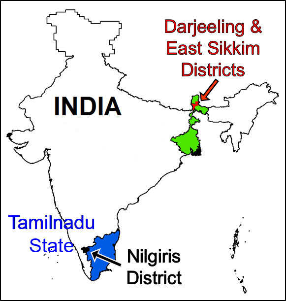
Our two pilot areas in India build upon existing, community-level landslide projects, enabling this project to draw upon participatory, community-led assessments of landslide risks and early warning needs. Both pilot areas are landslide prone, with population densities from very few to over 600 per km2. Both have experienced past events with fatalities and socio-economic impacts. Both experience intense rainfall during the north-east monsoon (October to December), which trigger landslides. Earthquakes are also a significant trigger of landslides in the north of India. Both pilot-study areas were chosen in direct collaboration with our GSI and Amrita teams, due to existing knowledge and data.
Pilot A: Darjeeling–East Sikkim, Himalaya, India (north-east India)
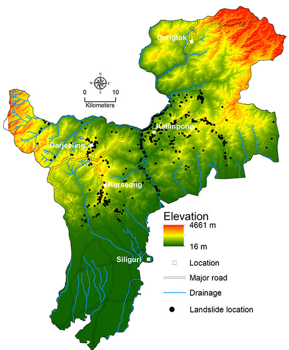
This rugged region consists of two districts in the Eastern Himalayas with elevations 65–4704 m above sea level (asl) (average 1213 m) and slope inclinations 0–60° (average approximately 18°).
Darjeeling District covers 3232 km2 (population approximately 1.9 million) with 75 per cent of its area landslide prone. East Sikkim covers 955 km2 (population approximately 0.3 million).
The Darjeeling–East Sikkim pilot area is underlain by a sequence of metamorphic rocks from the Himalayan Fold Thrust Belt (FTB). Landslide failure mechanisms encountered within this pilot area are controlled by FTB deformation of the rocks (folded and heavily faulted). Average annual rainfall in this region (mainly in the southern part, within Darjeeling Himalayas) varies between 300–500 cm yr−1, of which approximately 90 per cent is within the active monsoon period (June to October).
Pilot B: Nilgiris District, Western Ghats (southern India)
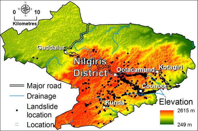
Nilgiris District (2566 km2; population approximately 0.8 million) includes the Nilgiri hills (1900 km2), one of the most landslide-prone regions in Tamil Nadu State, India. The Nilgiri hills are a plateau with elevations reaching 2400 m.
Two landforms define the plateau:
- high peaks and rocky escarpments marked by radial drainage patterns (Doddabetta landforms)
- plateau with gentle topography, with thick soil development and meandering streams
Archaean-aged charnockite and gneiss overlain by lateritic soils (thickness <1–32 m) are found in the Nilgiri hills. Almost 56 per cent of the total area in Nilgiris District is covered by forest. Out of the remaining area, 70 per cent is cultivated tea and coffee. The Nilgiri hills receive most of their rainfall during the north-east monsoon (October to December), when most landslides occur (largely debris/earth slides or flows).
Uttarakhand and Afghanistan (South-South knowledge sharing via workshops)
These two pilot-study areas will provide test platforms for the development of methodologies and tools applicable to other parts of India (e.g. Uttarakhand), Afghanistan, and south-east Asia in order to ensure knowledge transfer to other vulnerable national and district authorities.